The Wild Atlantic Way - Part 2
Northern Donegal
A series of articles about locations along this 2500km marked tourist route, which runs from Derry in the north to Kinsale in the south
Dunlewey (Lugh's Fort)
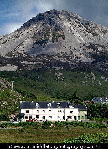
The little village of Dunlewey (Dún Lúiche) might otherwise be just another village if not for two great facts, one visible and the other not so visible. The first refers to the majestic sight of Mount Errigal, sitting dominantly beside the R251 road running through the hauntingly beautiful landscape of the Glenveagh National Park and the Derryveagh Mountains. This has to be one of the most magical places in Ireland and a great place to start your journey around Northern Donegal and this wonderful stretch of the Wild Atlantic Way.
At 751 metres it may not sound like much of a mountain to any hardcore mountaineers out there, but with its distinctive conical shape giving it the illusion of a volcano, and its status as the tallest peak in the Derryveagh range and the tallest in Donegal, it certainly stands out among the rest.
I’ve always found the light and the landscape in the northwest of Ireland to have a magical, silvery quality to it. Often when I have travelled here in bad weather, I’ve watched as shafts of light have broken through and illuminated the silvery mountain peaks that seem to beckon you on through the rain like a beacon of hope. It’s possibly the reason why many monasteries and shrines have been established here.
The silvery glow is actually the quartzite, which is the whitish-grey rock that forms the mountains here. Errigal’s conical shape and silvery glow has no doubt lured many a weary traveller over the centuries, not least of all the great warrior and Celtic demigod, Lugh of the Long Arm: so named because of his exceptionally long reach with a sword.
Lugh was the grandson of Balor of the Evil Eye, the wicked leader of the Formorians whose stronghold was on nearby Tory Island. Lugh was cast into the sea along with his two siblings because of a prophesy that foretold of how Balor would be slain by his grandson. But Lugh was rescued by Manannán mac Lir, the Sea God, and grew up in Spain. When he returned to Ireland he established a fort here under Errigal, known as Dún Lúiche (Lugh’s Fort)‘
The village is known today as Dunlewey. It’s a small place with a lakeside visitor centre and the Errigal Hostel. A walking trail starts from the back of the hostel and leads to the summit of the mountain. There is also another shorter trail that starts from the road further east of town.
The Poisoned Glen
The nearby area is known as the Poisoned Glen, just a short walk from the village. The area apparently got its name because of a typo, which resulted in an error when it was translated from Irish to English. The glen is a truly idyllic location surrounded by beautiful mountains and containing a lake with an old ruined church all backed by the majestic sight of Mount Errigal. Locals named it “An Gleann Neamhe” – (The Heavenly Glen), but when an English cartographer drew a map of the area, he wrote down “An Gleann Neimhe” – The Poisoned Glen.
However, I prefer this version of how the name came about. There are many stories of Balor’s death, one tells of how Balor came to Dunlewey one day and boasted about slaying his own grandchildren, unaware that Lugh was one of those children. Lugh became enraged and grabbed a red hot metal rod from the furnace and thrust it through Balor’s eye. The land ran red with his blood and the poison from his evil eye ran into the lake forming, and naming, the Poisoned Glen. Fulfilling the prophecy.
Hiking and cycling
Dunlewey is a great starting point for a journey around Northern Donegal County. There is a huge network of waymarked walking trails that will lead you through the Glenveagh National Park and onwards to the coast. It’s also a great location for a cycling holiday.
- Donegal Coast One Day Self-Guided E-Bike Tour

- Price: $55.84
- 8-Day Donegal Guided Walk

- Price: $1840.97
Grianán of Aileach
From Letterkenny you can take the N13 towards Derry. However, just before crossing the border turn right at the sign for Grianán of Aileach. The road leads up onto Grianán Mountain overlooking the main road where a huge circular stone enclosure sits on a flattened section of the hill surrounded by three earthen embankments.
Although it looks like a ring fort, experts actually believe it was an amphitheatre rather than a defensive structure. The present structure was rebuilt in the 1800s.
The inner diameter is 76 feet, and the outer wall stands 17 feet high and 13 feet thick. Local legend says that it was built by the Dagda in 1700BC as a temple of the sun. But this more than likely refers to the original earthen structures it’s built upon. From the 5th to 12th century this was the inauguration point of the Uí Neill clan.
Malin Head
Northwards is Malin Head, the northernmost point of Ireland. Along the way, stop at the village of Carndonagh, where three ancient stone crosses sit outside the present day church. St. Patrick’s Cross is the tallest at 8 feet, and the other two are dwarfed either side of it. Each cross is carved with simple figures depicting a mixture of Pagan and Christian symbols.
Fanad Lighthouse
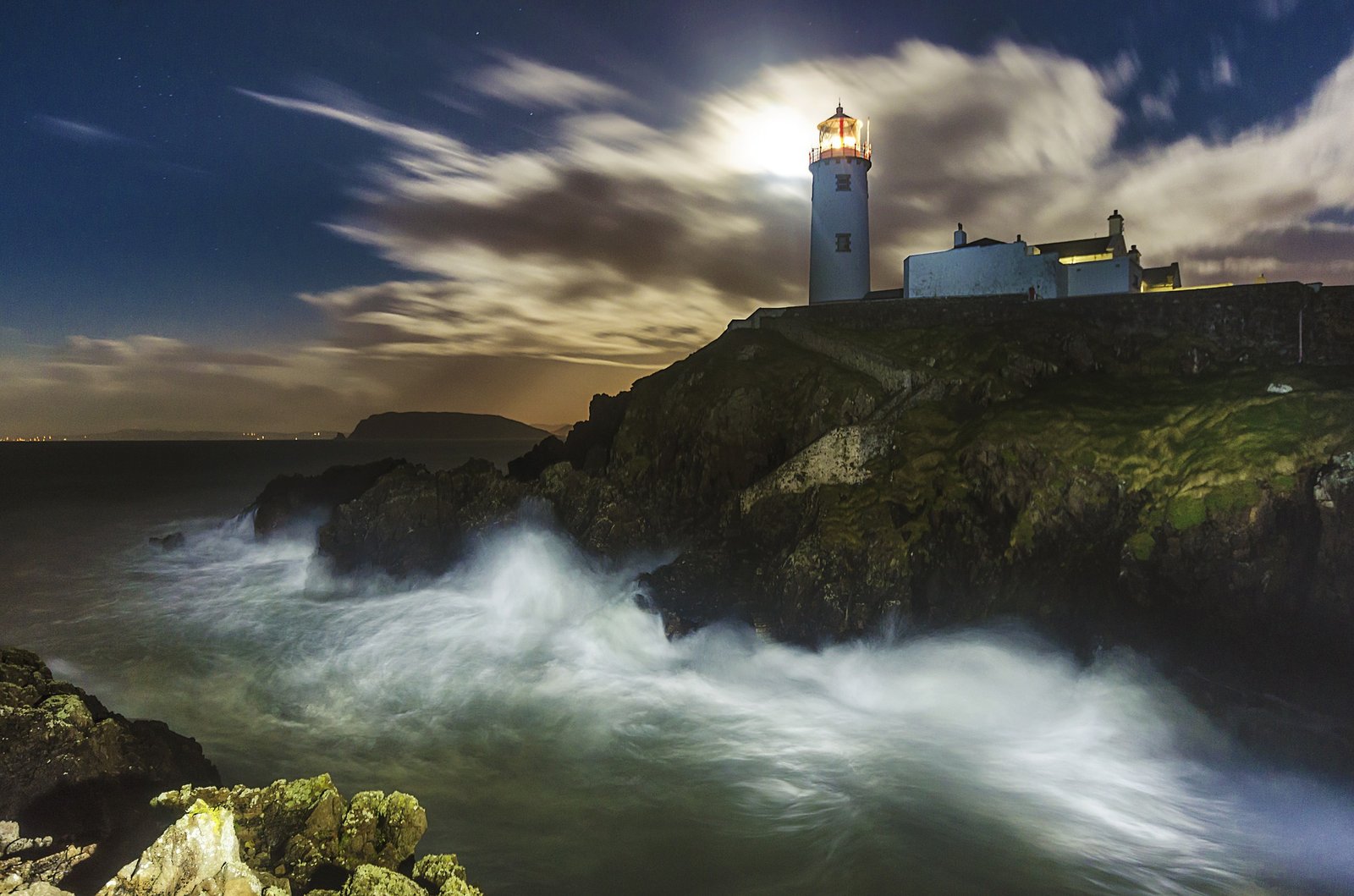
If you head back down to Letterkenny and take the R245 and R246 northwards you’ll soon be on the fabulous Fanad Peninsula. Keep going to the top and you’ll arrive at the equally fascinating Fanad Lighthouse.
Fanad is probably one of Northern Donegal’s most photogenic lighthouses and locations. It has been a working lighthouse since 1817 and open to the public as a tourist attraction since 2016.
If you would like to spend the night up here and really experience the rugged, wildness of this region then the lighthouse also offers unique overnight accommodation in three beautifully restored lightkeepers’ cottages.
- Donegal Ireland (Wild Atlantic Way) Photo Tour (5 days)

- Price: $1854.44
- Wild Atlantic Way Tours Donegal

- Price: $147.95
- Donegal Gaeltacht Private Tour

- Price: $555.88
- Donegal Wild Atlantic Tour

- Price: $287.11
The Bloody Foreland
Head back down from here and rejoin the N56. Continue northwards to Falcarragh and then to Gortahork. From here you can take the R257 coastal road along the Bloody Foreland to Bunbeg. This is a dramatic, rocky place where the reddish brown coastline lies like a serrated knife overlooked by wild and untamed hills. I never tire of driving along here.

Many of the islands off this coast have contained the remnants of villages that were abandoned decades back when the Irish government relocated the inhabitants to the mainland. This is a lovely place to just spend time walking along the empty beaches, exploring the rocky inlets and just enjoying the wonderful views of this rugged and unspoiled part of the world. Here you will feel a million miles away from the hustle and bustle of life.
Gweedore
As you head further west you’ll arrive in the area of Gweedore, which is one of the many Gaeltacht areas (Irish speaking regions).
This is a lovely corner of Donegal and contains some of the most incredibly pristine sandy beaches in Ireland. If not for the weather, you could well believe you were on a tropical island.
Bunbeg
The little village of Bunbeg has always been a personal favourite of mine, in particular Bunbeg Harbour. There are many places to stay in Northern Donegal, but the best place in my opinion is Bunbeg House. This charming guesthouse is located at Bunbeg harbour and run by Andy and Jean Carr. Andy will entertain you in his bar by night, and take you out on his rib boat during the day.

This is an ideal base from which to explore the rugged Northern Donegal Coast. Andy will even take you out to one of the islands where you can see the abandoned villages up close. From Bunbeg you can also take a ferry out to Tory Island.
Getting to Ireland
Dublin is the main airport for the Rep of Ireland, or else Belfast in Northern Ireland. If you are coming from within Europe then the following airlines are worth looking at.
Wizz Air: Personally I have always found them to be the best and offer the lowest fares.
Skyscanner: A great place to search and compare flights
Ebookers: Ebookers have been around for longer than most and have always offered a great choice of flights.
Getting around
CAR
The best way to get around Ireland is by car. Either take your own car or you can rent one easily from Dublin or any other major city. Here are three great places to look:
BUS
The national bus service connects most major cities, towns and villages and is a good way to get around, especially if you want to meet some locals
If you want a fun way to travel with other like-minded travellers then try the Paddywagon
TRAIN
The national train service also serves a lot of the larger towns and cities. Great for getting from one side of the country to the other.
Accommodation
Holidu: This is a great website to search for a variety of places to stay.
Hostelworld: If you are looking for budget accommodation then Hostelworld is a great place to search for a variety of backpacker hostels, B&Bs and hotels.
Wild Atlantic Way Part 1
Wild Atlantic Way Part 3
My Ireland Book
Read the story of my first ever trip around Ireland in my book, Hot Footing Around the Emerald Isle.
With just a backpack as a home, a guidebook in one hand, a bizarre travelogue in the other and very little money in my bank account, I leave my home and set off to this little country that has always been my neighbour, yet overlooked by myself for many years as I pursued dreams to travel to far and exotic countries. However, I was soon to learn that one of the most beautiful places in the world was right on my doorstep.







3 responses